|
2006 Trip to Nevada
< Back
If you haven't noticed yet, I have a
high interest in military aircraft and facilities, or anything
related. So where do you go after you explore The Mojave
Triangle? Why you go to Nevada! Not only is it home to Nellis AFB and Red Flag, its home
to the most secure Air Force Flight Test Center in the US.
About 100 miles north of Las Vegas is the famous base
"Area 51", "Groom Lake", "Watertown", "The Ranch", "Dreamland",
the list of names go on and on. Its home some of the most
advanced military planes around, and formerly home to planes
like the U-2, A-12/SR-71, and host to the F-117 and B-2.
Now you can't actually see the base very well without
optics since the land grab by the Air Force of near by Freedom
Ridge and White Sides mountains. The closest view point is about
26 miles to the south east on Tikaboo Peak, which has an elevation of
8000ft ASL. Hiking up to Tikaboo Peak was out of the question
for this trip, it was January, and around 11°F not including
wind-chill, and I only had plans to stay in Nevada for 4 days,
so I pretty well stayed in the car most of the time. I just
drove up to the border, took some photos of the signs and of the
camo dudes, went to the "Black Mailbox" and went on my way to
Rachel like most newcomers do. I hope to make the Tikaboo hike
next time I make a similar trip.
I also visited a few other places father north, like Bear
Paw dry lake, Base Camp, and Railroad Valley. The further North
you go the more beautiful it gets. Note that Bear Paw and
Railroad Valley have nothing to do with Area 51.
I didn't actually play around in Vegas, been there done
that sort of thing, so don't expect photos of Vegas here. The
only photos I took in Vegas were of the Janet 737-200s that
transport workers into the Nevada Test Site (NTS). I didn't
photograph anything at Nellis AFB either, I want to save that
one for another time.
I have NO interest in UFOs or Aliens! Just classified military
projects.
WARNING: There
are panoramas below that are up to 1.5
megabytes big.
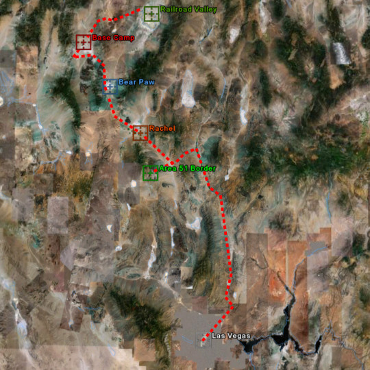
Map of My Trip
List of Sections
Click one to jump down to that
section.
Las Vegas Janet Terminal
Area 51 Border
-Black Mailbox
Rachel
Base Camp
|
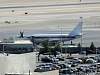
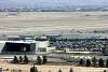
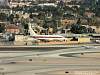
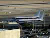
Las Vegas Janet Terminal Janets
are Boeing 737-200s, Beech 1900Cs and 200Cs owned and operated by EG&G
out of a discrete terminal on
the west side McCarran Intl. Airport. The 737s fly daily routes like any
other charter airline to Area 51, Tonopah Test Range, and occasionally
to Palmdale and Edwards. The Beech 1900Cs and 200Cs usually fly on trips
out of town, to public and military airports all over the US. They have
a total of six 737s, two 1900Cs, and three 200Cs, making a total of 11
aircraft. Since there are so many photos of the Janets, I'm only going
to comment on unique photos. Incase you are wondering, I was staying in
the Tropicana Hotel, which is where I shot most of these photos. For more info about Janet, visit
www.LazyGRanch.com &
www.DreamLandResort.com. |

Close up of the terminal. |

The two 1900Cs. |

One of the 737s.
|

|
|
 |
 |
 |

|
 |
 |
 |

|
 |
 |
 |
 |
 |

Usually there's one ready to takeoff when ones landing.
|
Here's one landing, taking off, and taxiing. |
 |
Offloading passengers.
|
 |
 |

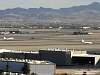
Shot showing the whole terminal. |

Night time shot of the whole terminal with all the planes
except for two of the 200Cs.
|
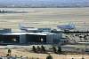
Here's a shot of all of the 737s, one with just the tail
sticking out, see it? |

Here's a ground shot of one of the 200Cs. |

Ground shot of one of the 1900Cs. |

Ground shot of one of
the 1900Cs.
|
|

Panorama of the whole Janet Terminal area looking south
east.

A wider view panorama
looking south east.

Panorama of the Janet Terminal looking to the west.
Jump Back Up |
Area 51 Border The
border of Area 51 is not fenced, and is marked by signs on Groom Lake
Road, off the road the border is only marked by small hard to see orange
posts. It is mainly patrolled by guys known as "Camo Dudes" (called that
because of the desert camouflage they ware) in trucks, and they just sit
up on their hill and watch you, as long as you don't cross the border,
they will leave you alone. Occasionally you will see an MH-60G Pavehawk
patrolling the border as well. Groom Lake Road has road sensors that
notify the Dudes to approaching cars, and some of the hill ridges have
cameras which I didn't see, but can be seen at
www.DreamlandResort.com
or
here and
here. Also for more info on the border go to
www.DreamlandResort.com. |
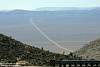
Very first thing I noticed as I passed through the Pahranagat Range into
Tikaboo Valley was Groom Lake Road (GLR).
|

GLR, the road you take to the border. |

This stretch of GLR starting from hwy 375 to the border is over 14
miles! |

Got to watch for those cows. |

A lone bird near GLR. |

Bald Mountain |

One of the signs at the border.
|

A set of signs
at the border. |

A wide photo of the signs at the border.
|

The "Camo Dudes". |

Close up on the "Dudes" |

A view looking east on GLR.
|

There's some cows down there, do you see them? |

A lot of light is emitted from Area 51 at night, and no the blue light
is not a UFO, its an Aircraft.
|

A panorama of the GLR area taken from a small hill. |
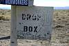
"Black Mailbox" Walk Around The
"Black Mailbox", which was replaced with a white one, is owned and
used by rancher Steve Medlin. The original Black Mailbox, as seen
here, was auctioned off for $1000 to a UFO fan. The mailbox is a
popular spot where people like to gather and watch the skies over Area
51 for lights at night.
Below are photos of all sides of the mailbox, showing
all the little notes and whatnots that have been added to it by visitors
over the years. Go here for more on the "Black Mailbox"
www.DreamlandResort.com. |

|
 |
 |
 |

|
 |
 |
 |

|
 |
 |
 |
|
Jump Back Up |
|
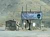
Rachel
Rachel is the closest town to Area 51, its a small
town with only about 100 people who live mostly in mobile homes. They
have a small shop and gas station called the Quick-Pik and a famous
little bar and grill/motel called the Little A'le'inn and formerly home
to the Area 51 Research Center. There's not much to see and do, but the
people are very nice. Go here for more on Rachel
www.Rachel-Nevada.com. |

Rachel from hwy 375. |

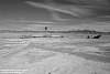
Sand Spring Valley Dry Lake from hwy 375 |

Old mining equipment? |

Hwy 375 was named the ET Highway after the whole Bob Lazar thing.
|

Closer view of part of Rachel. |

Sign near the Quick-Pik. |

The Quick-Pik. |

Little
A'le'inn sign and UFO recovery reenactment.
|

Little
A'le'inn |

Little
A'le'inn graphic close-up.
|
Jump Back Up |
|
Base Camp
Base Camp is a small airstrip used as a staging area,
for support, and as a recreation area for the military and contractors
and has several small houses. The facility was originally used by the
Atomic Energy Commission as a staging area during nuclear tests. It was
abandoned by the AEC and was taken over by the USAF. They repaved the
runway and made it longer, making it 7000ft and added several new
buildings. Its been claimed that it is now run by the Air Force Flight
Test Center Det. 3 which is based at Edwards AFB, and is the same people
who run Area 51. There's really nothing interesting here.
Go here for more on Base Camp
www.DreamlandResort.com. |

Some shops and buildings. |

More buildings and a tank.
|

Some housing and some sort of telescope. |

Close up of the housing.
|

A shot of the ramp area. |

Shot showing the VOR from the ramp area.
|

A better view of the ramp. |

Looking down the runway. |

The VOR. |

The NDB. |

Close-up on the runway. |

A shot showing the radome on top of Halligan Mesa, which is directly
inline with the runway at Base Camp.
|

A sign about the old mining town of Tybo. |
|
Jump Back Up |
|
Miscellaneous Photos
These are just a bunch of photos taken on the way to
the other places that don't belong in the other categories. |

Taken on the way to Vegas. |
Alien sign. |

Another alien sign. |

Old volcano near Lunar Lake.
|

Another old volcano
near Lunar Lake.
|
 |
 |
 |
 |
 |
 |

|
 |
 |

|

1 of 2 AV-8s that flew into McCarran.
|

2 of 2 AV-8s
that flew into McCarran. |

They parked near some unknown hangars south of the Janet terminal.
|

The next morning they left. |
 |

Shot of McCarran during sunset.
|
|

A panorama of Bear Paw dry lake, taken for a friend, has nothing to do
with Area 51.
|

A panorama of Railroad
Valley, taken for a friend, has nothing to do with Area 51.
|

Ok-ok so I took
a few photos of the strip. |

|
|
Jump Back Up |
< Back
Suggested sites to visit about
Area
51:
www.DreamlandResort.com
www.LazyGRanch.com
www.DesertSecrets.com
www.serve.com/mahood/bluefire.htm
|